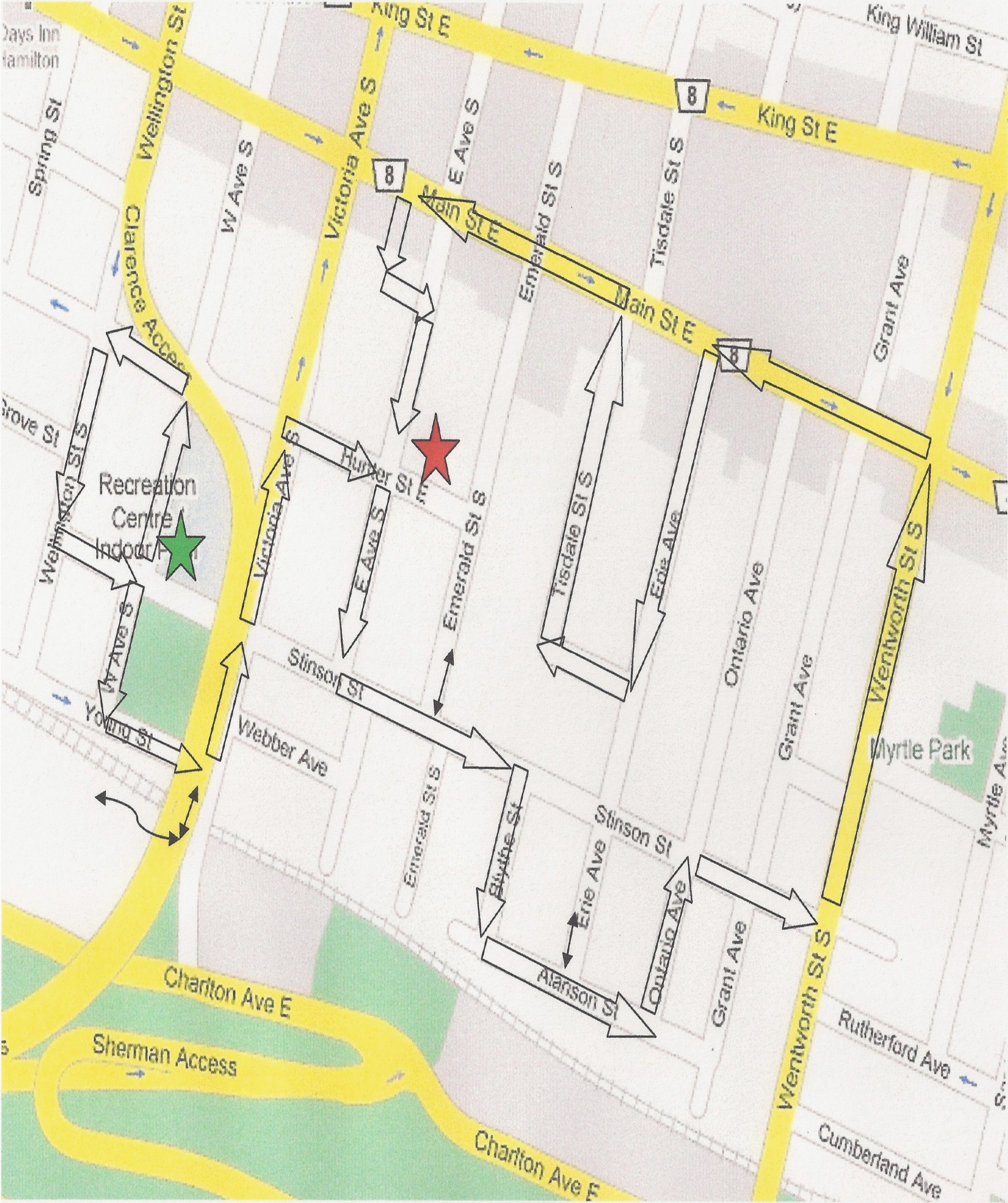
START.
Central Memorial Recreation Centre, 93 West Ave. S. (Note 102 West Ave. S. Originally built in 1876 with a verandah)
2. Mountain Access Island
3. Wellington St. S. / Hunter St. E. route to the GO station
4. Stinson St.
5. Carter Park
6. Young St.
7. Railway bridge underpass
8. Stairs to Rail Trail
9. Escarpment Rail Trail
10. Victoria Avenue. Mountain Access Wall. Joseph Lister’s home was 147 Victoria (now Webber Ave.)
11. Victoria Ave. renovations to single family homes
12. A Hamilton Blooms island?
13. Hunter and Victoria. Land owner’s house
14. East Ave. S.
15. Fearman House (now Emmanuel House)
16. 145 Emerald St. S. renovation
17. Blythe St.—The cutest little street in Stinson. The re was a Boy’s Home that stood at Stinson & Erie.
18. Alanson St.
19. 140 Erie Ave—Heritage designation
20. Stinson School Lofts
21. Wentworth St/ Wentworth St. stairs, entrance to Rail Trail. Wentworth Street Incline Railroad 1895-1936
22. Homestead Christian Care
23. Main St. E.—Boutique Spaces on North side
24. Main St. E @ Erie St.—Grocery Shopping and mall stores
25. Erie St.
26. Tisdale St.
27. O.A.T.C. Hamilton Clinic
28. Cathedral High—Wilma’s Place (Alternative School)
29. Luba Mera Institute of Aesthetics and Cosmetology
30. Hearing Institute
31. Central Health Institute
32. Alleyway between Victoria Ave. S. and East Ave. Also Alleyway running parallel to Main St. E.
33. East Ave. S.
END
Bishop’s Park
You have just walked approximately 3.6 km.
You have had a glance of all 17 streets and 7 alleyways that make up our neighbourhood.
Stinson’s land area is 1 square km (86 acres)
Our population as at the 2006 Census was 3,894
The average age of the population is 38.9 years old and consists of young singles, families and single parents. Residents here tend to move often and have a high rate of employment in transportation, manufacturing and sales.
Approximately 70% of all dwellings are rented, 30% owned
The primary businesses are health related; dentists, doctors, education, pharmacy, and care facilities.